Место работы автора, адрес/электронная почта: Институт мерзлотоведения им. П. И. Мельникова СО РАН ; 677010, г. Якутск, ул. Мерзлотная, 36 ; e-mail: fedorov@mpi.ysn.ru ; http://mpi.ysn.ru
Ученая степень, ученое звание: канд. геогр. наук
Область научных интересов: Геокриология, ландшафтоведение
ID Автора: SPIN-код: 6083-1651, РИНЦ AuthorID: 61293
Деятельность: С 1979 г. работает в Институте мерзлотоведения СО АН СССР.
Количество страниц: 16 с.
Assessing the resilience of landscapes in response to current climate warming represents a critical challenge today. The current intensification of cryogenic processes in Central Yakutia, particularly in disturbed and anthropogenic landscapes, highlights the urgency of this issue. This study aims to evaluate the thermal stability of permafrost landscapes in Central Yakutia amid increasing climate warming since the 1970s. The assessment is based on field observations of permafrost rock temperatures within the annual heat turnover layer from 1981 to 2023, alongside meteorological data on air temperature at 2 meters above ground and soil temperature at a depth of 1.6 meters. The primary research method involved monitoring, including establishing a network, observation at sites and monitoring stations of the Melnikov Permafrost Institute of SB RAS, and analyzing the collected data in the context of climate change. Spatiotemporal changes in the thickness of the active layer and the mean annual temperature of ground within the annual heat turnover layer were estimated, with their trends serving as indicators of the landscape’s response to climate warming. A regional analysis of the variability of the thermal stability coefficient (Кα) of permafrost rocks across nine types of localities was conducted, based on temperature data at the base of the active layer and within the annual heat turnover layer (10 meters depth). Positive Кα values exceeding 1.0 indicate permafrost degradation, while negative trends are associated with changes in snow accumulation regimes and ecosystem biomass. Assessing the thermal stability of permafrost landscapes has significant implications for the natural environment and the socio-economic stability in Central Yakutia. The research findings can inform government agencies in territorial development planning and support environmental organizations, businesses, and educational institutions.
Варламов, С. П.
Оценка термической устойчивости мерзлотных ландшафтов к современному потеплению климата (на примере Центральной Якутии) / С. П. Варламов, Ю. Б. Скачков, А. Н. Федоров ; Институт мерзлотоведения им. П. И. Мельникова СО РАН // Природные ресурсы Арктики и Субарктики. - 2025. - Т. 30, N 3. - С. 376-391. - DOI: 10.31242/2618-9712-2025-30-3-376-391
DOI: 10.31242/2618-9712-2025-30-3-376-391
Количество страниц: 11 с.
In recent years, forest fires have demonstrated an increasing trend in Yakutia, associated with modern global warming and extensive activation of cryogenic processes. In Central Yakutia, an ice complex is widespread, confined to the inter-alas type of terrain. Thawing of the ice component of the soils leads to the development of thermokarst, which is observed in disturbed treeless areas. The general climatic conditions, lithological and geocryological characteristics of the areas for which numerical modeling of the thermal state of soils was performed are described. The thermal state of inter-alas soils in 8 areas after forest fires was modeled during vegetation restoration, taking into account the current trend of increasing air temperature by 0.02о/year. The models were compiled for key periods of change in surface conditions and vegetation: 3, 8, 10 and 25 years after forest fires. It was revealed that in the Pokrovsk, Borogontsy and Berdigestyakh areas, it is possible to reach the depth of thawing of the ice horizon, which is due to high mean annual air temperatures and the spread of sandy loam in the upper part of deposits. And if the vegetation is not restored within the first three years, then presumably cryogenic processes will occur in these areas. In other areas, according to the modeling results, thawing does not reach the ice complex; gradual self-restoration of vegetation should bring geocryological conditions to their original state within 20-25 years. Soil temperatures are expected to rise, which is related to the current general warming of the climate. If the warming trend continues, thawing and soil temperature increases will be more significant and noticeable.
Новоприезжая, В. А.
Расчетные геокриологические характеристики межаласий после лесных пожаров в Центральной Якутии / В. А. Новоприезжая, А. Н. Федоров ; Институт мерзлотоведения им. П. И. Мельникова // Вестник Северо-Восточного федерального университета им. М. К. Аммосова. Серия "Науки о Земле". - 2025. - N 3 (39). - С. 67-77. - DOI: 10.25587/2587-8751-2025-1-67-77
DOI: 10.25587/2587-8751-2025-1-67-77

Год выпуска: 2024
Ответственность: Шумилов Юрий Васильевич (Редактор), Максимов Григорий Николаевич (Автор обозрения, рецензии), Саввинов Григорий Николаевич (Автор обозрения, рецензии)
Издательство: Издательство Института мерзлотоведения СО РАН
Год выпуска: 2000
Количество страниц: 114 с.
Горохов, Алексей Николаевич.
Ландшафтно-экологический анализ бассейна р. Амги / А. Н. Горохов, Д. Д. Саввинов, А. Н. Федоров ; ответственный редактор Ю. В. Шумилов ; рецензенты: Г. Н. Максимов, Г. Н. Саввинов ; Сибирское отделение РАН, Институт прикладной экологии Севера, Институт мерзлотоведения им. акад. П. И. Мельникова СО РАН. - Якутск : Издательство Института мерзлотоведения СО РАН, 2000. - 109 с.

Год выпуска: 1991
Количество страниц: 144 с.
- Институт мерзлотоведения им. П.И. Мельникова СО РАН > Публикации,
- Краеведение. Археология. География. Биографии. История > Общие вопросы. География как наука. Географические исследования,
- Математика. Естественные науки > Общая геология . Метеорология. Климатология. Историческая геология. Стратиграфия. Палеогеография,
- НАУКА ЯКУТИИ > МАТЕМАТИКА. ЕСТЕСТВЕННЫЕ НАУКИ > Геология. Геологические и геофизические науки,
- НАУКА ЯКУТИИ > КРАЕВЕДЕНИЕ. ГЕОГРАФИЯ. БИОГРАФИИ. ИСТОРИЯ > Общие вопросы. География как наука. Географические исследования.
Федоров, Александр Николаевич.
Мерзлотные ландшафты Якутии: методика выделения и вопросы картографирования / А. Н. Федоров ; ответственные редакторы: В. И. Климовский, Н. А. Граве ; Академия наук СССР, Сибирское отделение, Институт мерзлотоведения. - Якутск : [б. и.], 1991. - 140 с.
Количество страниц: 9 с.
- Математика. Естественные науки > Геология. Геологические и геофизические науки,
- Краеведение. Археология. География. Биографии. История > Общие вопросы. География как наука. Географические исследования,
- НАУКА ЯКУТИИ > МАТЕМАТИКА. ЕСТЕСТВЕННЫЕ НАУКИ > Геология. Геологические и геофизические науки,
- НАУКА ЯКУТИИ > КРАЕВЕДЕНИЕ. ГЕОГРАФИЯ. БИОГРАФИИ. ИСТОРИЯ > Общие вопросы. География как наука. Географические исследования.
Presently, the climate is warming, with average annual temperatures rising every year, and theArctic remaining one of the most vulnerable regions. This has a noticeable e ect on the northern forests, which leads to the displacement of the tundra zone. Assessing the consequences of a projected increase in air temperature under climate change conditions requires spatial and instant monitoring of hard-to-reach areas. In the last few years, the use of remote sensing techniques and combinations of satellite imagery to calculate vegetation indices has generated great interest in obtaining high-de nition ground data. The article presents the results of modeling soil moisture in Anabar tundra, which is located in the north-west of Yakutia. The study was conducted on the border of tundra and forest tundra in three reference areas (tundra, tundra young forest, tundra indigenous forest). The simulation is presented by comparing the eld data and the normalized di erence index of humidity NDMI. The NDMI index uses the NIR and SWIR channels, calculates a multi-channel raster object and creates a raster image with index values from -1 to 1, which show the humidity level with a spatial resolution of 10 meters. The data showed that the value of humidity pixels according to NDMI in the tundra zone is 0.04, in the tundra young forest is 0.09 and, in the tundra, native forest is 0.15. It was found that the index data correlated with eld humidity data obtained from a depth of 0.2 m. A comparison of remote sensing decryption data with eld data made it possible to simulate the spatial distribution of soil moisture over the vast study area by extrapolation.
Никифорова, Н. Н. Моделирование весовой влажности грунтов на территории Анабарской тундры с использованием наземных исследований и данных дистанционного зондирования земли / Н. Н. Никифорова, С. В. Калиничева, А. Н. Федоров ; Институт мерзлотоведения им. П. И. Мельникова // Вестник Северо-Восточного федерального университета им. М. К. Аммосова. Серия: Науки о земле. - 2023. - N 4 (32). - C. 60-68. - DOI: 10.25587/2587-8751-2023-4-60-68
DOI: 10.25587/2587-8751-2023-4-60-68
Количество страниц: 5 с.
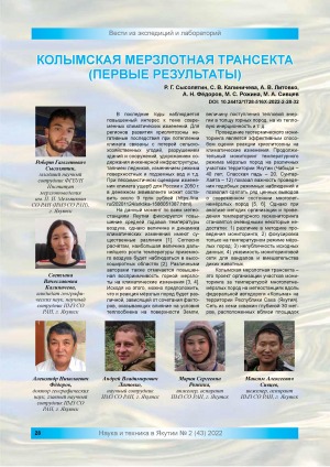
Колымская мерзлотная трансекта : (первые результаты) / Р. Г. Сысолятин, С. В. Калиничева, А. В. Литовко [и др.] ; Институт мерзлотоведения им. П. И. Мельникова // Наука и техника в Якутии. - 2022. - N 2 (43). - С. 28-32. - DOI: 10.24412/1728-516X-2022-2-28-32
DOI: 10.24412/1728-516X-2022-2-28-32
Год выпуска: 2020
Год выпуска: 2021
Год выпуска: 2021